September 12, 2024 - Planning Commission [Planning Commission]
Published
December 27, 2024
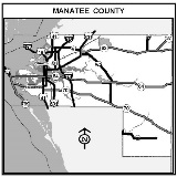
Notice of Zoning Changes in Unincorporated Manatee County
September 12, 2024
NOTICE IS HEREBY GIVEN, that the Planning Commission of Manatee County will conduct a Public Hearing on September 12, 2024, at 9:00 a.m. or as soon thereafter as same may be heard at the Manatee County Government Administrative Center, 1st Floor, Patricia M. Glass Chambers, 1112 Manatee Avenue West, Bradenton Florida to consider, act upon, and forward a recommendation to the Board of County Commissioners on the following matters:
PDC-24-02(Z)(G) – SR 70/UIHLEIN ROAD COMMERCIAL – SMR NORTHEAST LLC (OWNER) – PLN2402-0018
An Ordinance of the Board of County Commissioners of Manatee County, Florida regarding land development, amending the Official Zoning Atlas (Ordinance No. 15-17, as amended, the Manatee County Land Development Code) relating to zoning within the unincorporated area; providing for the rezoning of approximately 7.90 acres from the A/WP-E/ST (General Agriculture/Watershed Protection-Evers/Special Treatment) to the PDC/ST/WPE (Planned Development Commercial/Special Treatment/Watershed Protection-Evers Reservoir) Zoning District; generally located at the northwest corner of Uihlein Road and State Road 70 East, and commonly known as 14400 Covenant Way, Bradenton (Manatee County); approving a General Development Plan for a maximum of 79,149± square feet of commercial uses; approving a Schedule of Permitted and Prohibited Uses as voluntarily proffered by the Applicant and attached as Exhibit B; subject to stipulations as conditions of approval; setting forth findings; providing for severability; providing a legal description, and providing an effective date.
PDMU-23-49(Z)(G) – PENLER REZONE – WILLIAM CURTIS LANGFORD AND ROBERTA LEE LAGFORD, AND SHER-ROCK-RAND RANCH (OWNERS) – BRIAN METZLER (CONTRACT PURCHASER) - PLN2309-0144
An Ordinance of the Board of County Commissioners of Manatee County, Florida, regarding land development, amending the official zoning atlas (Ordinance 15-17, as amended, the Manatee County Land Development Code), relating to zoning within the unincorporated area; providing for a rezone of two parcels totaling 20.19 ± acres generally located on the south side of State Road 64 East, approximately 0.3 miles east of 117 Street E and 0.27 miles west of Pope Road, and commonly known as 12108 and 12310 State Road 64 East, Bradenton (Manatee County) from A (General Agriculture) to PDMU (Planned Development Mixed-Use); approving a General Development Plan for 300 multifamily residential units and 50,000 square feet of commercial uses; and approving a schedule of permitted and prohibited uses as voluntarily proffered by the applicant attached as Exhibit B, subject to stipulations as conditions of approval; setting forth findings; providing a legal description; providing for severability; and providing an effective date.
PDMU-15-03(G)(R) – FT. HAMER COMMONS – NORTH RIVER LAND LV LLC (OWNER) – PLN2402-0072
An Ordinance of the Board of County Commissioners of Manatee County, Florida, regarding land development, approving a revised General Development Plan for a mixed-use development consisting of 496 residential units (single-family detached, semi-detached, attached and multifamily); and neighborhood and community serving commercial uses ranging from 30,000 to 300,000 square feet; approving a Schedule of Permitted and Prohibited uses as voluntarily proffered by the applicant attached as Exhibit B; and deleting reference to the NCO (North Central Overlay District) from the Zoning Ordinance and General Development Plan in accordance with applicable law; on approximately 55.19 acre site zoned PDMU (Planned Development Mixed Use); generally located at the northeast quadrant of Fort Hamer Road and Mulholland Road and commonly known as 2700 Ft. Hamer Road, Parrish (Manatee County); subject to stipulations as conditions of approval; setting forth findings; providing a legal description; providing for severability; and providing an effective date.
PDMU-23-55(Z)(G) – THE VIBE @ UMR – MOORES DAIRY FARMS INC (OWNER) – PLN2311-0105
An Ordinance of the Board of County Commissioners of Manatee County, Florida, regarding land development, providing for a rezone of approximately 52.86 acres generally located on the east side of Upper Manatee River Road NE, approximately 1,000 feet south of 3rd Avenue NE, and 150 feet north of 2nd Avenue E, including two parcels commonly known as 115 Upper Manatee River Road NE and 11410 2nd Avenue NE, Bradenton (Manatee County) from A-1 (Agricultural Suburban) and A-1/CPA (Agricultural Suburban/Coastal Planning Area Overlay District) to PDMU (Planned Development-Mixed Use) and PDMU/CPA (Planned Development-Mixed Use/Coastal Planning Overlay District); approving a General Development Plan for up to 232 multi-family residential units and up to 100,000 square feet of low and medium intensity recreational facilities; subject to stipulations as conditions of approval; setting forth findings; providing a legal description; providing for severability; and providing an effective date.
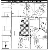
PDR-24-04(Z)(P) – KMF - AFFORDABLE - MANATEE / SANDRA K. DRACH, TRUSTEE; UNDER AGREEMENT DTD 4/20/06 (Owner)–KOLTER GROUP ACQUISITIONS, LLC (Contract Purchaser)- PLN2402-0118
An Ordinance of the Board of County Commissioners of Manatee County, Florida, regarding land development, amending the Official Zoning Atlas (Ordinance 15-17, as amended, the Manatee County Land Development Code), relating to zoning within the unincorporated area; providing for a rezone of an approximately 18.3-acre site, containing Parcel 1 (8.2 acres) and Parcel 2 (10.1 acres) which are adjacent parcels, from A-1/ CPA/ CHHA/AI (Agriculture Suburban/ Coastal Planning Area/Coastal High Hazard Area/Airport Impact) to PDR (Planned Development Residential) Zoning District, retaining the Overlays Districts; generally located at the southwest corner of Prospect Road and Saunders Road (63rd Avenue East), and commonly known as 6350 and 6480 Prospect Road, Sarasota (Manatee County); approving a Preliminary Site Plan for 312 multifamily units with at least twenty-five percent (25%) of the units designated as Affordable Housing; subject to a proposed Land Use Restriction Agreement (LURA); subject to stipulations as conditions of approval; setting forth findings; providing a legal description; providing for severability; and providing an effective date.
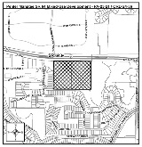
Z-23-31 - SKYWAY TRAILERS REZONE– SKYWAY TRAILERS LLC (OWNER) – PLN2310-0107
An Ordinance of the Board of County Commissioners of Manatee County, Florida, regarding land development, amending the Official Zoning Atlas (Ordinance 15-17, as amended, the Manatee County Land Development Code), relating to zoning within the unincorporated area, providing for a rezone of approximately 7.63 acres generally located north of 17th Street East (Memphis Road) and south of 21st Street Court East on the west side of Ellenton Gillette Road (36th Avenue East) at 1827 36th Avenue E, Palmetto (Manatee County) from A-1 (Agricultural Suburban) to LM (Light Manufacturing) Zoning District; setting forth findings; providing a legal description; providing for severability; and providing an effective date.
ZL-23-33 – EJ-MANATEE, LLC REZONE – EJ-MANATEE LLC (OWNER) – PLN2310-0046
An Ordinance of the Board of County Commissioners of Manatee County, Florida, regarding land development, amending the Official Zoning Atlas (Ordinance 15-17, as amended, the Manatee County Land Development Code), relating to zoning within the unincorporated area; providing for a rezone of two (2) parcels, approximately 15.84 acres, from NC-M (Neighborhood Commercial - Medium) to the GC/L (General Commercial /Limited) Zoning District; generally located at the northeast corner of State Road 70 (53rd Avenue East) and 33rd Street East extending north to 51st Avenue East, commonly known as 5201 33rd Street East, Bradenton (Manatee County); subject to stipulations as conditions of approval; setting forth findings; providing a legal description; providing for severability, and providing an effective date.
All interested parties may appear and be heard at the meeting with respect to the proposed Ordinances, subject to proper rules of conduct. Additionally, any written comments filed with the Director of the Development Services Department will be heard and considered by the Planning Commission.
It is important that all parties present their concerns to the Planning Commission in as much detail as possible. The issues identified at the Planning Commission hearing will be the primary basis for the final decision by the Board of County Commissioners.
Interested parties may examine the Official Zoning Atlas, Ordinances, the applications, related documents, and may obtain assistance regarding these matters from the Manatee County Development Services Department, 1112 Manatee Avenue West, 4th Floor, Bradenton, Florida, telephone number (941) 748-4501x6878; e-mail to .
Rules of procedure for this public hearing are in effect pursuant to Resolution 22-051. A copy of this Resolution is available for review or purchase from the Development Services Department (see address below).
Please send comments to: Manatee County Development Services Department
Attn: Agenda Coordinator
1112 Manatee Ave. West 4th Floor Bradenton, FL 34205 [email protected]
According to Section 286.0105, Florida Statutes, if a person decides to appeal any decision made with respect to any matters considered at such meetings or hearings, he or she will need a record of the proceedings, and for such purpose, he or she may need to ensure that a verbatim record of the proceedings is made, which record would include any testimony or evidence upon which the appeal is to be based.
Americans with Disabilities: The Board of County Commissioners does not discriminate upon the basis of any individual's disability. Manatee County is committed to providing full access to facilities, programs, and services to all, as well as supporting the employment of qualified individuals with disabilities in its workforce in accordance with federal and state laws and regulations, including the Americans with Disabilities Acts of 1990 (ADA) and as amended (“ADAA”), and 503 and 504 of the Rehabilitation Act of 1973. Anyone requiring reasonable accommodation for this meeting as provided for in the Americans with Disabilities Act (ADA), or assistance with accessing any of these documents, should contact Carmine Demilio, ADA Compliance Coordinator, at (941)792-4501 ext. 6016 or [email protected], as least 3 business days prior to the scheduled meeting. If you are deaf/hard of hearing and require the services of an interpreter, please contact the Florida Relay Service at 711.
THIS HEARING MAY BE CONTINUED FROM TIME TO TIME PENDING ADJOURNMENTS.
MANATEE COUNTY PLANNING COMMISSION
Manatee County Development Services Department
Manatee County, Florida
Date Published: August 29, 2024
Notice of Land Development Code Changes in Unincorporated Manatee County
September 12, 2024
The Manatee County Planning Commission will hold a public hearing to consider amendments to certain provisions of the Manatee County Land Development Code (Ordinance 15-17, as amended) and make recommendations to the Board of County Commissioners as to the consistency of the proposed Ordinances with the Comprehensive Plan and as to whether the proposed ordinances should be adopted, adopted with modifications, or denied.
Date: September 12, 2024
Time: 9:00 AM or soon thereafter as same may be heard
Place: Manatee County Government Administrative Center 1st Floor Honorable Patricia M. Glass Chambers
1112 Manatee Avenue West
LDCT-24-06 / ORDINANCE 24-75 COUNTY-INITIATED LAND DEVELOPMENT CODE TEXT AMENDMENT FENCES AND WALLS PLN2405-0170
An Ordinance of the Board of County Commissioners of Manatee County, Florida, amending the Manatee County Land Development Code; providing for purpose and intent; providing findings; amending Land Development Code Chapter 5 – Standards for Accessory and Specific Uses and Structures, Section 511.6., Fences and Walls, providing for other amendments as may be necessary for internal consistency; providing for codification; providing for applicability; providing for severability; and providing an effective date.
All interested parties may appear and be heard at the meeting with respect to the proposed Ordinance, subject to proper rules of conduct. Additionally, any written comments filed with the Director of the Development Services Department will be heard and considered by the Planning Commission.
It is important that all parties present their concerns to the Planning Commission in as much detail as possible. The issues identified at the Planning Commission hearing will be the primary basis for the final decision by the Board of County Commissioners. Interested parties may examine the Official Zoning Atlas, Ordinances, the applications, related documents, and may obtain assistance regarding these matters from the Manatee County Development Services Department, 1112 Manatee Avenue West, 4th Floor, Bradenton, Florida, telephone number (941) 748-4501x6878; e-mail to [email protected].
The hearing may be continued from time to time to a date and time certain or to no date certain and re-advertised. The public may also provide written comments for the Planning Commission to consider.
Rules of procedure for this public hearing are in effect pursuant to Resolution 22-051. A copy of this Resolution is available for review or purchase from the Development Services Department (see address below).
Please send comments to: Manatee County Development Services Department
Attn: Planning Coordinator
1112 Manatee Ave. West 4th Floor
Bradenton, FL 34205
941-748-4501 ext. 6878
Interested parties may appear and be heard at the meeting with respect to the proposed ordinances.
Americans with Disabilities: The Board of County Commissioners does not discriminate upon the basis of any individual's disability. Manatee County is committed to providing full access to facilities, programs, and services to all, as well as supporting the employment of qualified individuals with disabilities in its workforce in accordance with federal and state laws and regulations, including the Americans with Disabilities Acts of 1990 (ADA) and as amended (“ADAA”), and 503 and 504 of the Rehabilitation Act of 1973. Anyone requiring reasonable accommodation for this meeting as provided for in the Americans with Disabilities Act (ADA), or assistance with accessing any of these documents, should contact Carmine DeMilio, ADA Compliance Coordinator, at (941)792-4501 ext. 6016 or [email protected], as least 3 business days prior to the scheduled meeting. If you are deaf/hard of hearing and require the services of an interpreter, please contact the Florida Relay Service at 711.
Interested parties may examine the proposed Ordinances and related documents and may obtain assistance regarding these matters from the Manatee County Development Services Department, 1112 Manatee Avenue West, 4th Floor, Bradenton, Florida; telephone number (941) 748-4501 EXT. 6878; e-mail to: [email protected]
According to Section 286.0105, Florida Statutes, if a person decides to appeal any decision made with respect to any matters considered at such meetings or hearings, he/she will need a record of the proceedings, and for such purpose, he/she may need to ensure that a verbatim record of the proceedings is made, which record would include any testimony or evidence upon which the appeal is to be based.
SAID HEARING MAY BE CONTINUED FROM TIME TO TIME PENDING ADJOURNMENTS.
MANATEE COUNTY PLANNING COMMISSION
Manatee County Development Services Department
Manatee County, Florida
Date Published: August 29, 2024
Notice of Comprehensive Plan Amendment
September 12, 2024
The Manatee County Planning Commission will hold a public hearing to consider amendments to the Manatee County Comprehensive Plan and changes to the restrictions affecting certain lands within the unincorporated area of Manatee County with the intent to make a recommendation to the Board of Manatee County Commissioners:
Date: September 12, 2024
Time: 9:00 A.M. or soon thereafter
Place: Manatee County Government Administration Building
1st Floor Patricia M. Glass Chambers
1112 Manatee Avenue West
Bradenton, Florida
Additional amendments to the following may be necessary to implement these changes and ensure internal consistency.
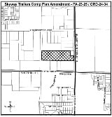
PA-23-25 / ORDINANCE 24-34 SKYWAY TRAILERS PRIVATELY-INITIATED SMALL-SCALE COMPREHENSIVE PLAN MAP AMENDMENT PLN2310-0106
An Ordinance of the Board of County Commissioners of Manatee County, Florida, regarding Comprehensive Planning, amending Manatee County Ordinance No. 89-01, as amended (the Manatee County Comprehensive Plan); providing a purpose and intent; providing findings; providing for a Privately-Initiated, Small-Scale Map Amendment to the Future Land Use Map of the Future Land Use Element on approximately 7.63 acres to designate specific real property generally located at the northwest quadrant of the intersection of Ellenton Gillette Road (County Road 683) and 17th Street East (Memphis Road), and commonly known as 1827 36th Avenue East (Manatee County) from RES-9 (Residential – 9) to the IL (Industrial Light) Future Land Use Classification; providing for severability and providing an effective date.
PA-23-21 / ORDINANCE 24-36 PENLER CPA – SMALL-SCALE COMPREHENSIVE PLAN MAP AND TEXT AMENDMENT PLN2309-0143
Adoption of an Ordinance of the Board of County Commissioners of Manatee County, Florida, regarding Comprehensive Planning, amending Manatee County Ordinance No. 89-01, as amended (The Manatee County Comprehensive Plan); providing a purpose and intent; providing findings; providing for a Privately-Initiated Map and Text Amendment to Element 2 - Future Land Use of the Comprehensive Plan amending the Future Land Use Classification (FLUC) of approximately 20.19 ± acres of real property, consisting of two adjacent parcels, generally located on the south side of SR 64, approximately 0.3 miles east of 117 Street E and approximately 0.77 miles west of Rye Road, commonly known as 12108 and 12310 SR 64 E, Bradenton (Manatee County), from UF-3 (Urban Fringe – 3 DU/GA) FLUC to the ROR (Retail/ Office/ Residential) FLUC; providing for a specific property development condition in the text of Element 2, Future Land Use Element, Policy 2.14.1.28 / D.5.28 regardless of any established Land Use Equivalency Matrix (LUEM) or Density/Intensity Bonuses, the project shall be a mixed-use development, limited to a maximum number of 300 dwelling units and 50,000 square feet of non-residential uses; providing for severability; and providing an effective date.
PA-24-02 / ORDINANCE 24-32 KMF AFFORDABLE – SMALL-SCALE COMPREHENSIVE PLAN MAP AND TEXT AMENDMENT PLN2401-0120
Adoption of an Ordinance of the Board of County Commissioners of Manatee County, Florida, regarding Comprehensive Planning, amending Manatee County Ordinance No. 89-01, as amended (The Manatee County Comprehensive Plan); providing a purpose and intent; providing findings; providing for a Privately-Initiated Map and Text Amendment to Element 2 - Future Land Use of the Comprehensive Plan amending the Future Land Use Classification (FLUC) of approximately 18.3 ± acres of real property generally located at the southwest corner of Prospect Road and Saunders Road (63rd Avenue East), commonly known as 6350 Prospect Road and 6480 Prospect Road, Sarasota (Manatee County), from RES-6 (Residential – 6 DU/GA) FLUC to the RES-9 (Residential – 9 DU/GA) FLUC; providing for a specific property development condition in the text of Element 2, Future Land Use Element, Policy 2.14.1.27 / D.5.27 regardless of any established Land Use Equivalency Matrix (LUEM) or Density Bonuses, the project shall be limited to a maximum density of 17.0 dwelling units per acre and shall be developed for residential uses only. Furthermore, the applicant shall enter into a Land Use Restriction Agreement regarding the provision of affordable housing units; providing for severability; and providing an effective date.
PA-24-08 / ORDINANCE NO. 23-22 (CORRECTIVE) COMMUNITY RATING SYSTEM (CRS) CLASS “4” (COUNTY OWNED PROPERTY) COUNTY-INITIATED LARGE SCALE COMPREHENSIVE PLAN MAP AMENDMENT PLN2406-0044
An Ordinance of the Board of County Commissioners of Manatee County, Florida, regarding Comprehensive Planning, amending Manatee County Ordinance No. 89-01, as amended (the Manatee County Comprehensive Plan); providing a purpose and intent; providing findings; providing for a CORRECTIVE County-Initiated Large Scale Map Amendment to the Future Land Use Map of the Future Land Use Element to designate specific real property generally located at 2425 Tallevast Road (Manatee County) from P/SP (1) (Public/Semi-Public (1)) to the IH (Industrial Heavy) Future Land Use Classification (36.28± acres), 16410 Rangeland Parkway (Manatee County) from R/OS (Recreation/Open Space) to the MU-C/R (Mixed Use - Community/Residential) Future Land Use Classification (74.27± acres) and 5895 Post BLVD Unit 17 (Manatee County) from R/OS (Recreation/Open Space) to the MU-C/AC-1 (Mixed Use – Community/Activity Center Level 1) Future Land Use Classification (124.39± acres); totaling approximately 234.94 acres; and providing for severability and providing an effective date.
PA-24-09 / ORDINANCE NO. 23-24 (CORRECTIVE) GENERAL CLEAN UP (COUNTY OWNED PROPERTY) COUNTY-INITIATED SMALL SCALE COMPREHENSIVE PLAN MAP AMENDMENT PLN2406-0045
An Ordinance of the Board of County Commissioners of Manatee County, Florida, regarding Comprehensive Planning, amending Manatee County Ordinance No. 89-01, as amended (the Manatee County Comprehensive Plan); providing a purpose and intent; providing findings; providing for a CORRECTIVE County-Initiated Small Scale Map Amendment to the Future Land Use Map of the Future Land Use Element to designate specific real property generally located at the southeast quadrant of the intersection of Rangeland Parkway and Post Boulevard (Manatee County) from P/SP (1) (Public/Semi-Public (1)) to the MU-C/R (Mixed Use – Community/Residential) Future Land Use Classification (16.546± acres) and from P/SP (1) (Public/Semi-Public (1)) to the MU-C/R (Mixed Use/Community Residential) and the MU-C/AC-1 (Mixed Use – Community/Activity Center Level 1) Future Land Use Classifications (19.454± acres); totaling 36.00 acres; and providing for severability and providing an effective date.

Americans with Disabilities: The Board of County Commissioners does not discriminate upon the basis of any individual's disability. Manatee County is committed to providing full access to facilities, programs, and services to all, as well as supporting the employment of qualified individuals with disabilities in its workforce in accordance with federal and state laws and regulations, including the Americans with Disabilities Acts of 1990 (ADA) and as amended (“ADAA”), and 503 and 504 of the Rehabilitation Act of 1973. Anyone requiring reasonable accommodation for this meeting as provided for in the Americans with Disabilities Act (ADA), or assistance with accessing any of these documents, should contact Carmine DeMilio, ADA Compliance Coordinator, at (941)792-4501 ext. 6016 or [email protected], as least 3 business days prior to the scheduled meeting. If you are deaf/hard of hearing and require the services of an interpreter, please contact the Florida Relay Service at 711.
The Public is invited to speak at this hearing, subject to proper rules of conduct. The hearing may be continued from time to time to a date and time certain. The Public may also provide written comments for the Board of County Commissioners to consider.
Rules of Procedure for this public hearing are in effect pursuant to Resolution 22-051. Copies of this Ordinance may be obtained from the Development Services Department (See address below).
Please Send Comments To: Manatee County Development Services Department
Attn: Supervisor, Planning and Zoning – Agenda Division
1112 Manatee Ave West, 4th Floor
Bradenton, FL 34206
All written comments will be entered into the record.
For More Information: Copies of the proposed amendments will be available for review and copying at cost approximately seven (7) days prior to the public hearing. Information may also be obtained by calling 748-4501, Ext. 6878, between 8:00 AM and 5:00 PM.
According to Section 286.0105, Florida Statutes, if a person decides to appeal any decision made with respect to any matters considered at such meetings or hearings, he/she will need a record of the proceedings, and for such purpose, he/she may need to ensure that a verbatim record of the proceedings is made, which record would include any testimony or evidence upon which the appeal is to be based.
Date Published: August 29, 2024
Public Notices
Interested parties may examine the proposed Ordinances, Resolutions and related documents and may obtain assistance regarding this matter from the Manatee County Development Services Department located at:
1112 Manatee Avenue West
4th Floor
Bradenton, Florida
(941) 748-4501 x6878
[email protected]
All interested parties may appear and be heard at the meeting with respect to the proposed Ordinances. According to Florida Statutes, Section 286.0105, any person desiring to appeal any decision made by the Board of County Commissioners with respect to any matter considered at said Public Hearing will need a record of the proceedings, and for such purposes, he may need to ensure that a verbatim record of the proceedings is made, which includes the testimony and evidence upon which the appeal is to be based.
Rules of procedure for Public Comment and Citizens’ Comments (including time limits) are governed by Resolution R-25-013, Restated Rules of Procedure (adopted 1/28/25).
Americans with Disabilities: The Board of County Commissioners of Manatee County, Florida, does not discriminate on the basis of an individual's disability. Manatee County is committed to providing full access to facilities, programs, and services to all, as well as supporting the employment of qualified individuals with disabilities in its workforce in accordance with federal and state laws and regulations, including the Americans with Disabilities Acts of 1990 (ADA) and as amended ("ADAA"), and 503 and 504 of the Rehabilitation Act of 1973. Anyone requiring reasonable accommodation for this meeting as provided for in the Americans with Disabilities Act (ADA), or assistance with accessing any of these documents, should contact Carmine DeMilio, ADA Compliance Coordinator, at (941) 748-4501, ext. 6016 or [email protected], at least 3 business days prior to the scheduled meeting. If you are deaf/hard of hearing and require the services of an interpreter, please contact the Florida Relay Service at 711.
THESE HEARINGS MAY BE CONTINUED FROM TIME TO TIME PENDING ADJOURNMENTS.